Top Cades Cove Hiking Trails

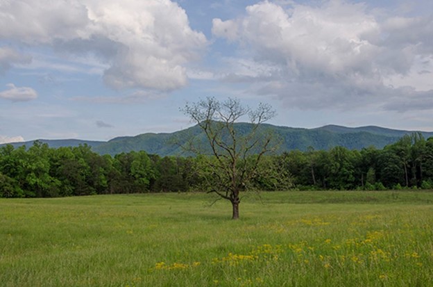
Cades Cove is a favorite destination for many people visiting the Smokies with its broad, lush, green valley surround by mountains. More than 11 million people coming through the Smokies each year, and nearly 4 million of them choose a trip to Cades Cove for its beauty, history, and wildlife. There are terrific hiking trails around Cades Cove, which Located 27 miles from Gatlinburg and 9 miles from the lovely Townsend, TN.
Along the trails, which range from short and gentle to challenging, are waterfalls, caverns, monuments, a grist mill, and incredible natural life. Hikers might see white-tailed deer, black bear, coyote, ground hog, turkey, raccoon, skunk, and many other animals.

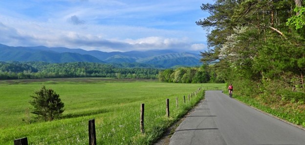
Let’s start with the famous Cades Cove Loop Road. The 11-mile road is closed to all vehicles on Wednesdays from May 3 to Sept. 27 in 2023 to provide for pedestrian and bicycle use. It’s a GREAT day to plan a hike in this incredible place uninterrupted by cars traversing the loop.
Cades Cove Nature Trail
If you’re looking for something short and gentle for all ages in the family, check out the Cades Cove Nature Trail. This 0.8-mile walk is a loop hike gaining only 210’ in elevation. Pass over creeks through the dense forest and get a new appreciation for the valley.
Appalachian Trail
Abrams Falls Trail is a five-mile roundtrip challenging hike to Abrams Falls. Longer hikes to Thunderhead Mountain and Rocky Top on the famous Appalachian Trail also begin in the cove.
At approximately 2.6 miles, hikers will turn left to the footbridge and come out to a beach area where they can observe the 20-foot waterfall named for Cherokee Chief, Abram. Make sure to stay close to the beach and avoid the falls if you are tempted to cool off in the water. The unique geologic structure of this waterfall makes the pool too dangerous for swimming. Splash close to the beach or head downstream to enjoy deeper pools. Abrams Falls is approximately 5.2 miles round trip, so give yourself at least 6 hours to enjoy the walk. And if you go on a Wednesday, you’ll walk 5 miles along the loop road as well.
Self-Guided
An inexpensive self-guiding tour booklet available at the entrance to the road provides a map and information about the cove.
Secret Waterfall
This “secret waterfall” is a must for any hike around Cades Cove. Spruce Flats Falls is a local favorite for getting a quick walk in the woods.

On the way to or from Cades Cove, turn off at the Tremont Road. Follow the signs to the Tremont Institute and park there. From the parking area, wander up the hill on a gravel road and follow the signs for the Buckeye Trail. Pass through parts of the Tremont Institute property before intersecting a second trail.
Take a left and head up a short, but steep hill. At the top, be rewarded with views of the road below and Thunderhead Mountain and the famous Appalachian Trail above. A short downhill will lead to a unique foot log with carved in steps on the way to the waterfall. The trail is a bit more rugged here with rocks and tree roots, but it is easy to follow.
The tiered waterfall makes a few unique places to explore, and the stream isn’t too deep for a quick splash. Return by reversing the trail for a challenging but fun 1.4-mile walk.
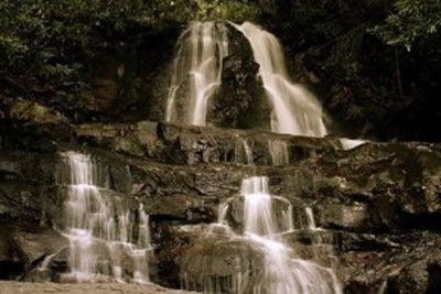
Abrams Falls
If something a little longer is on your list, drive approximately 5 miles on Cades Cove Loop Road to the Abrams Falls Trail. Follow the brown sign pointing you to the right down the gravel road to park. This popular hike gets busy, so make sure to arrive early! You’ll follow this wide, well-traveled trail out to a 20-foot-high waterfall. The forest surrounding is mostly oaks and evergreens on the ridge and makes for a serene setting.

At approximately 2.6 miles, hikers will turn left to the footbridge and come out to a beach area where they can observe the falls. Make sure to stay close to the beach and avoid the falls if you are tempted to cool off in the water. The unique geologic structure of this waterfall makes the pool incredibly dangerous for swimming. Splash close to the beach or head downstream to enjoy deeper pools. Abrams Falls is approximately 5.2 miles round trip, so give yourself at least 6 hours to enjoy the walk.
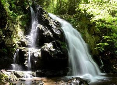
Laurel Falls
Laurel Falls is one of the most popular sites in the Great Smoky Mountains National Park and is named for the mountain laurels– the evergreen shrub that are prevalent throughout the Cades Cove region and blooms along the Laurel Falls Trail each year. This waterfall is 80-feet tall and has an upper and lower section divided by a walkway that crosses over the stream of the upper falls.
From Sugarlands Visitor Center, turn toward Cades Cove on Little River Road and drive 3.5 miles to the trailhead where there are parking areas on both sides of the road. Laurel Falls Trail is 2.6 miles round trip and is considered moderate difficulty. On average it takes about 2 hours to hike to the waterfall and back.
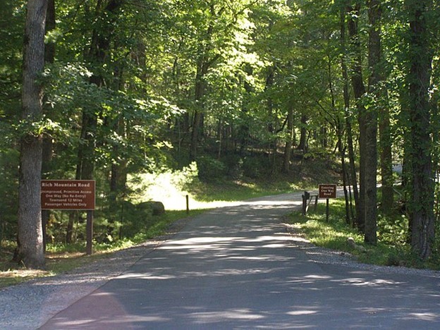
Rich Mountain Loop
If a more challenging hike is what you crave, the 8.5-mile Rich Mountain Loop is a great way to spend the day. Many people choose to hike this loop clockwise. Park at the interpretive pavilion in the large lot on the left BEFORE driving into the loop. You’ll see the trailhead to your right just before the loop begins. While at first you’ll be hiking at low elevations, the real climb begins just after the historic Oliver Cabin. Climb for nearly three miles before you reach the junction to the old Rich Mountain fire tower. You will have gained nearly 1800 feet in elevation, or approximately 600 feet per mile, to get here.
The trail opens up from footpath to wide wagon road before again winding it’s way down the Crooked Arm Ridge Trail. Beautiful views of Cades Cove will be your reward on the way down. Make sure to bring a map from the visitor’s center on this trip, where you’ll be combining a series of trails to create this loop hike. This hike is 8.5 miles round trip, so be sure to give yourself 9 hours to enjoy the hike and take breaks throughout the day.
Many people choose to hike this loop clockwise – so they park at the interpretive pavilion in the large lot on the left BEFORE driving into the loop. The trailhead is to the right just before the loop begins. Low elevations are first and then the real climb begins just after the historic Oliver Cabin. Climb for nearly three miles to reach the junction to the old Rich Mountain fire tower – it’s a gain of almost 1,800 feet in elevation.
Ace Gap
Ace Gap is located 3.5 miles from Townsend, Tennessee, and is considered one of the most peaceful trails in Cades Cove. The 5 ½ miles has little altitude gain or loss. The trailhead is down Cades Cove Loop and up Rich Mountain Road. Near the trailhead, hikers pass Bull Cave, the largest cave in Cades Cove. The bottom of the cave is 500 feet from the surface. Once beyond the cave, the trail meanders five miles along the ridges of Rich Mountain to the place known as Ace Gap. “Ace Gap was so named for card playing loggers that once congregated there. You will know you have come to Ace Gap when you come to an old railroad bed.”
During May, parts of the Ace Gap trail are strewn with pink Lady’s Slippers a large, showy wildflower that belongs to the orchid family. According to the National Park Service, all wildflowers in Cades Cove are protected by law, so no picking or digging, but admire and photograph!
CADES COVE PICNIC AREA
If a day of hiking, driving, and horseback riding has you a bit hungry you can take advantage of the Cades Cove Picnic Area. If you’re heading out of the loop, the picnic area is directly on your right side before heading back down Laurel Creek Road. This picnic area is first-come, first-serve basis with 81 individual sites, each with a picnic table and grill. There are also bathrooms with potable water. If you’re here on a hot summer afternoon, make sure to cool off in one of the two mountain streams nearby. Some picnic sites are even adjacent to the water.
Didn’t pack a lunch or dinner? No problem! Cades Cove Trading Company is nestled between the picnic area and the campground. The deli offers made-to-order food, as well as grab-and-go options. The camp store has chips, sodas, snacks, and, of course, ice cream.
CADES COVE FULL MOON WALK
You’re in for a real treat if your family is visiting during a full moon. Cades Cove is an incredible place to walk under the stars since the Loop Road is closed at night. Park at the interpretive pavilion and grab your flashlights. Bring your headlamp with a red light, or red cellophane for your flashlight. This will help you maintain your night vision. Walk out and back as far as your family desires, observing the stars and the moon without any light pollution. Turn off your headlamp and be guided by the moonlight if you’re feeling brave!
If your crew is feeling ambitious, you can walk down to Sparks Lane, approximately one mile from the parking lot. Turn left onto the gravel road and follow it until you reach pavement again, approximately one mile. Walk back on the paved Loop Road and follow the signs to the parking area for an approximately 3.5-mile walk.
If you want to learn more about this amazing place, check out this video by the Great Smoky Mountains Association:
For more Cades Cove trails, check out this guide to search by difficulty rating, by location, by feature or alphabetically.
CABINS NEAR CADES COVE
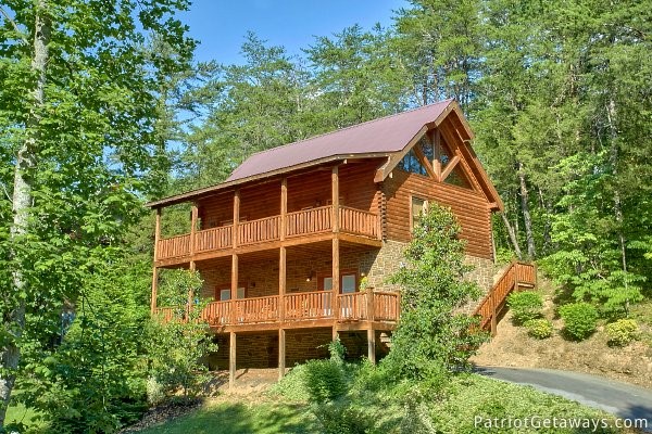
Booking a cabin in Wears Valley makes perfect sense when you are planning hikes in Cades Cove. Check out our great Wears Valley area cabins and find your perfect vacation destination!
Give our Reservations staff a call at 800-204-5169 or check out our website. No matter your group size or budget, American Patriot Getaways has a cabin for you!
Be sure to follow us on Facebook and Instagram to keep up to date with all the latest area information. Check us out on Pinterest for easy recipes to cook in your cabin, decor inspiration, and more!
The post Top Cades Cove Hiking Trails appeared first on American Patriot Getaways.
Published on Thursday, May 11, 2023